VR acquired the Junction property in August, 2017. The property has been expanded by additional staking by the Company several times through 2018 based on positive exploration data. VR has expertise to leverage and synergies to exploit at Junction from ongoing work at its nearly Bonita porphyry cu-au property, a grass-roots exploration program which began in 2014 and advanced to first-pass drill-testing in 2018.
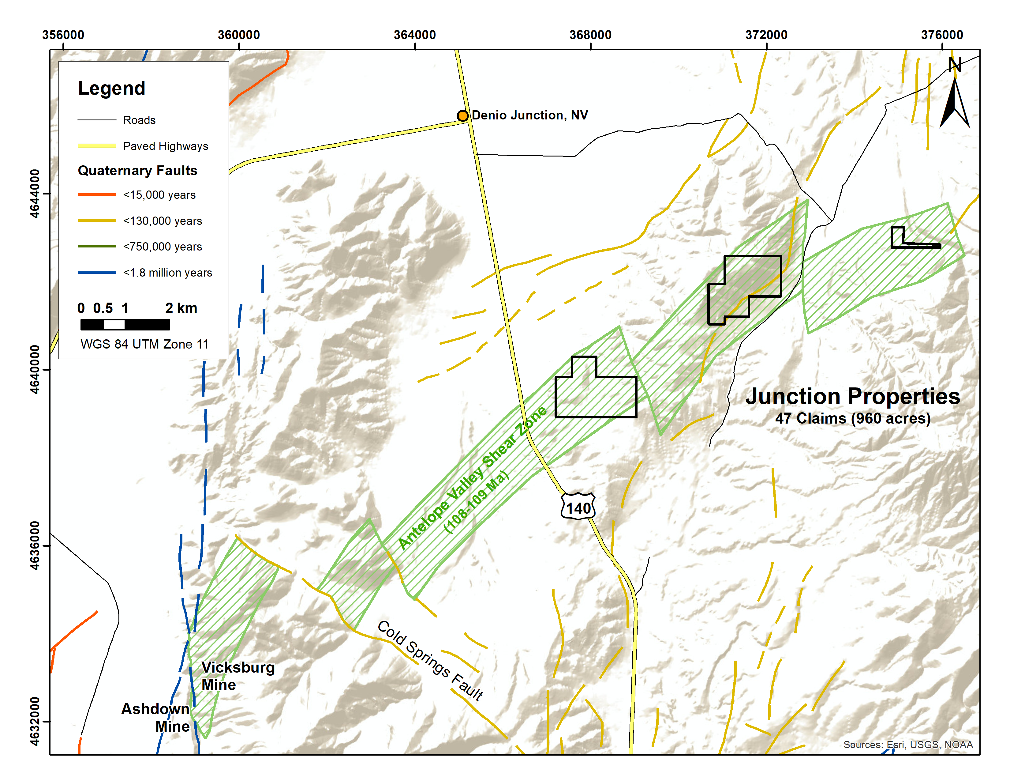
The Junction property is little explored because of its location outside of Nevada’s well-established mineral deposit belts. Polymetallic granite dykes and associated gold-bearing quartz veins occur at surface along a 6 kilometre trend at Junction, and have the potential to be the high level expression of a rooted, hydrothermal-magmatic porphyry system at depth, related to a polyphase Cretaceous batholith, for which Nevada has large and proven porphyry copper systems of similar age. The Junction property is located in the Antelope Shear zone, which provides a crustal-scale anchor for the high temperature, copper-silver-gold metasomatic and/or magmatic-hydrothermal mineralizing fluid system.
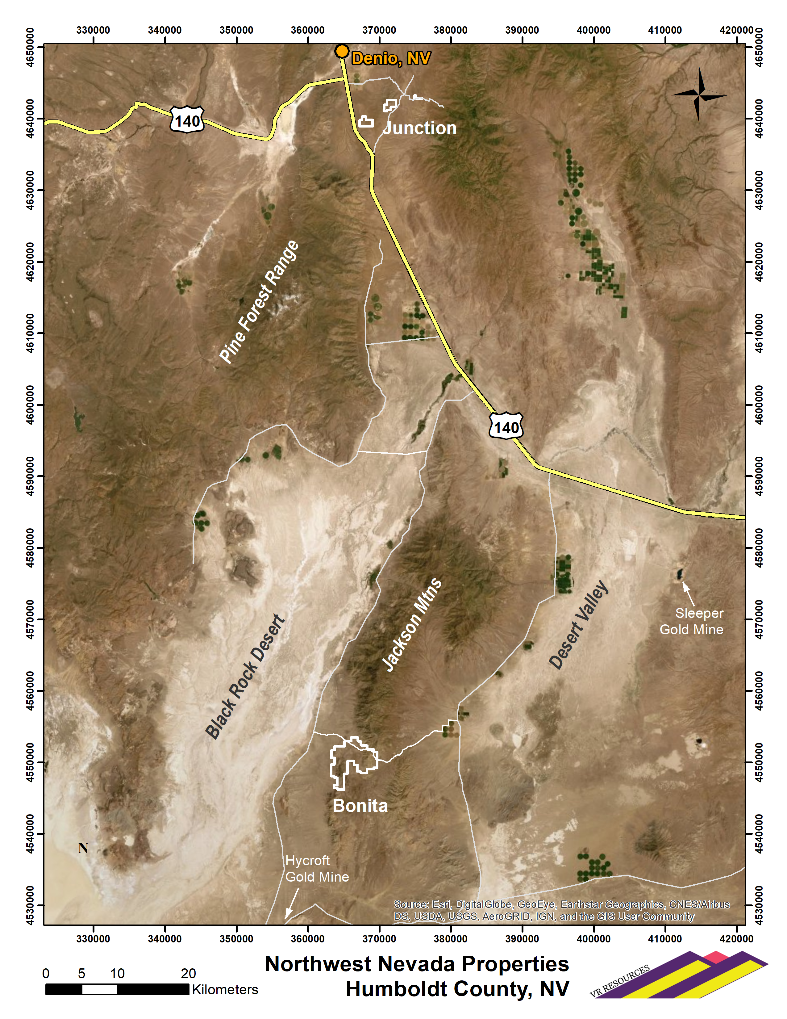
The Junction property is located in Humboldt County, near the Nevada – Oregon border, and immediately east of Nevada Highway 140. The nearby town of Denio Junction is less than 6 kilometres to the north, and facilitates effective and cost-efficient field exploration programs.
The Junction property is at the northernmost limit of the Pine Forest Range. Topography at Junction is subdued. Desert valley floors give way to grassy rangelands on rounded and low-lying foothills of the low-elevation craggy ridgeline of Lone Mountain. There are no pine nor juniper at Junction.
There is abundant outcrop at Junction. Where outcrop is not exposed, colluvium is interpreted to be local in nature; there is no soil development, nor thick basin pediment cover. Rounded knolls and low relief scarps have a regolith veneer typically less than 30 centimetres thick on top of weathered outcrop. There are thin veneers of Tertiary-aged basalt locally.
The Junction property consists of 47 claims in three separate blocks which collectively cover an area of 388 hectares (960 acres) along the 6 km long trend of mineral showings.
The property is on land administered by the federal Bureau of Land Management (BLM). There are no state or federal land use designations which restrict exploration on the property, nor is the property within the BLM’s broadly defined area of sage grouse protection.
The property is owned 100% by VR, registered to the Company’s wholly-owned, Nevada-registered US subsidiary Renntiger Resources USA Ltd. There are no carried interests or back-in interests on the property. Most of the claims were staked directly by VR, but certain claims in the western-most and eastern-most part of the property were acquired privately; terms of the respective acquisitions, including royalty terms, are outlined in news releases dated August 30, 2017, and April 5th, 2018, and available on this website.
The 2018 surface exploration program at Junction commenced in April. Work includes:
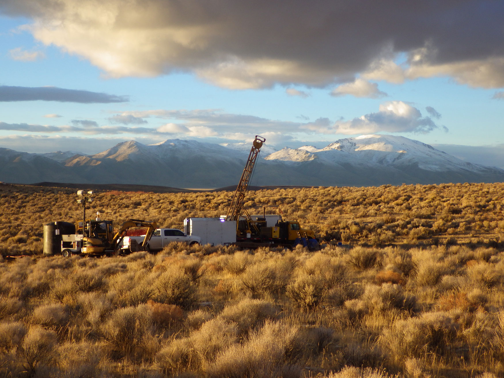
- First pass diamond drill program in the late fall of 2018, including one hole on each of two separate targets at either end of the six kilometre trend of copper-silver bearing dykes, for a total of 731 metres. A total of 114 drill core samples were taken for geochemistry. Results of the drill program are summarized in the news release dated January 29, 2019, and available on this website.
- Airborne EM survey: high resolution VTEM-Max survey of 20 lines at 100 metre spacing covering 2 x 3 km block over Wilder Creek target, to map copper sulfide and high resistivity silica alteration along the 1.3 km strike-length of surface copper showings;
- Ground gravity survey: property grid of 437 stations collected over 13 by 4 kilometer block on 400 metre station grid, with 200 metre infills over key targets;
- Induced Polarization geophysical survey (IP): two test lines, 3 kilometres long each, over the Denio Summit gravity anomaly and adjacent surface copper-silver showings and copper-silver-gold-tungsten soil anomaly;
- Airborne magnetic and radiometric survey: 84 lines on 200 metre spacing, with 100 metre spaced infills over key targets, for 433 line-kilometers overall covering a 12 by 5 kilometre survey block coincident with the ground-based gravity survey;
- Soil Sampling: 343 soil samples on 12 lines covering the various showings along the Lone Mountain trend and at the Wilder Creek target in the central and eastern part of the property, to augment the detailed existing survey of 347 soil samples on 16 lines covering the Denio Summit target in the western part of the property.
VR completed first pass geological mapping, prospecting, rock sampling and grid-based soil sampling in September through November, 2017:
- 102 rock samples collected from on and around the property for geochemistry;
- 307 soil samples collected at 25 and 50 metre stations on 16 lines spaced 100 metres apart.
- 13 hand samples for physical property testing, including density, conductivity, resistivity and magnetic susceptibility, and;
- 4 hand samples for plain light and polished section mineral petrology
The property is underlain mostly by a magnetic, medium grained, amphibolite-grade biotite-hornblende orthogneiss, a quartz monzodiorite in composition, and locally feldspar porphyroblastic. A more leucocratic orthogneiss of monzo-granite composition is mapped in the eastern part of the property. Migmatitic zones of disharmonically folded leucosome within melanocratic orthogneiss is mapped at the outcrop-scale locally throughout the property. The orthogneiss forms the northeastern part of the Early Cretaceous Antelope Valley shear zone which extends for some 20 km’s to the southwest to the Ashdown mine. Structural grain of the shear zone is northeast-southwest, generally dipping steeply northwest.
Orthogneiss units at the Junction property are part of an Early Cretaceous, batholith-scale polyphase intrusive complex which is broadly contemporaneous with the Antelope Valley shear zone; the tectonic history is well constrained by geological mapping and age dates and research in the Pine Forest Range area (e.g. Geologic Map of the Vicksburg Canyon Quadrangle, Humboldt County, Nevada; Map 169, Nevada Bureau of Mines and Geology, 2010). Plutonic phases of the batholith include gabbro, quartz monzodiorite and granodiorite which range in age from 107 to 111 million years old; orthogneiss at the Junction property belongs to the 110 Ma Lone Mountain quartz monzodiorite along the northwestern margin of the batholith. Strain on the Antelope shear zone is bracketed to circa 106 – 107 Ma, cut by a late granodiorite dyke phase of the batholith; copper-bearing quartz feldspar pegmatite dykes described below for the Junction property are thought to be related to this final period of the polyphase batholith.
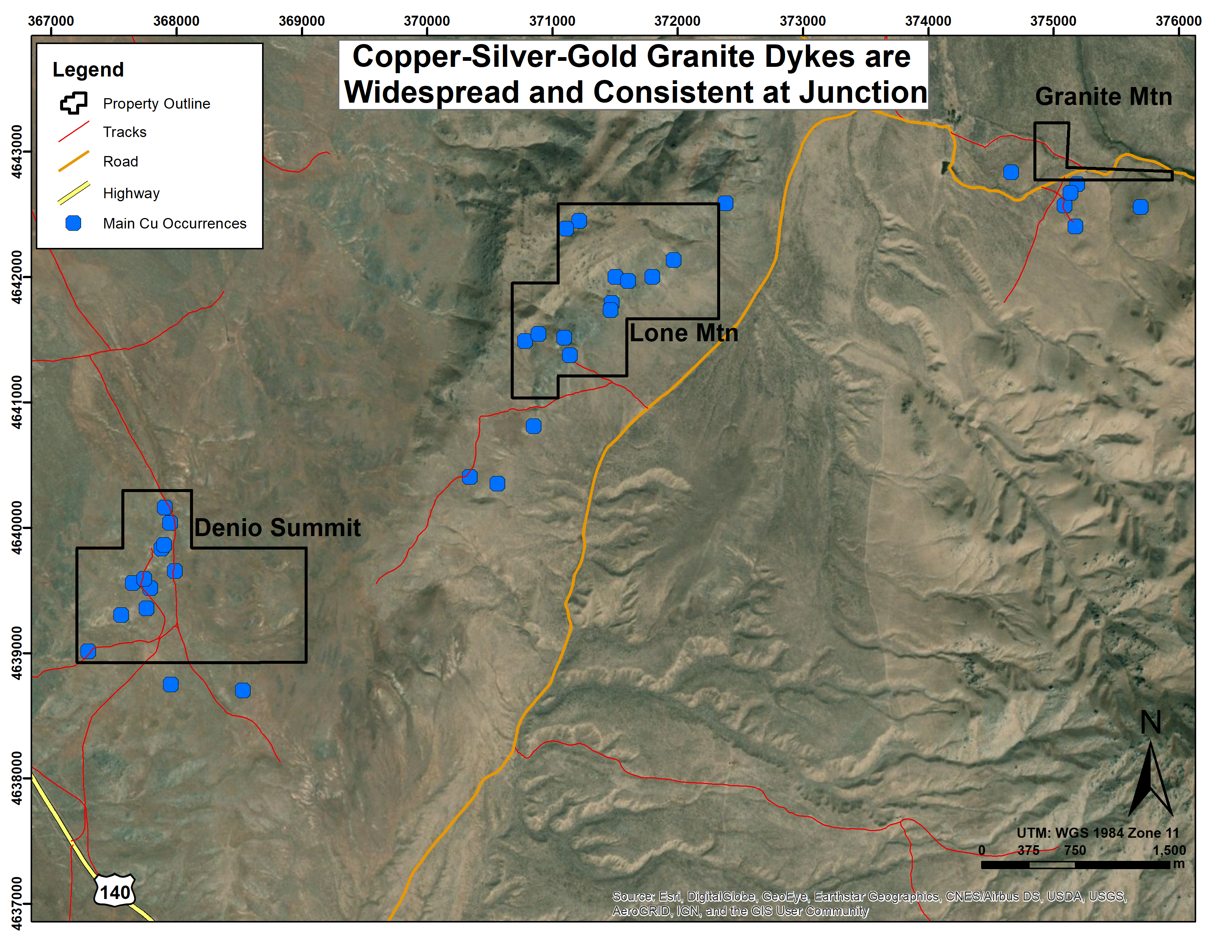
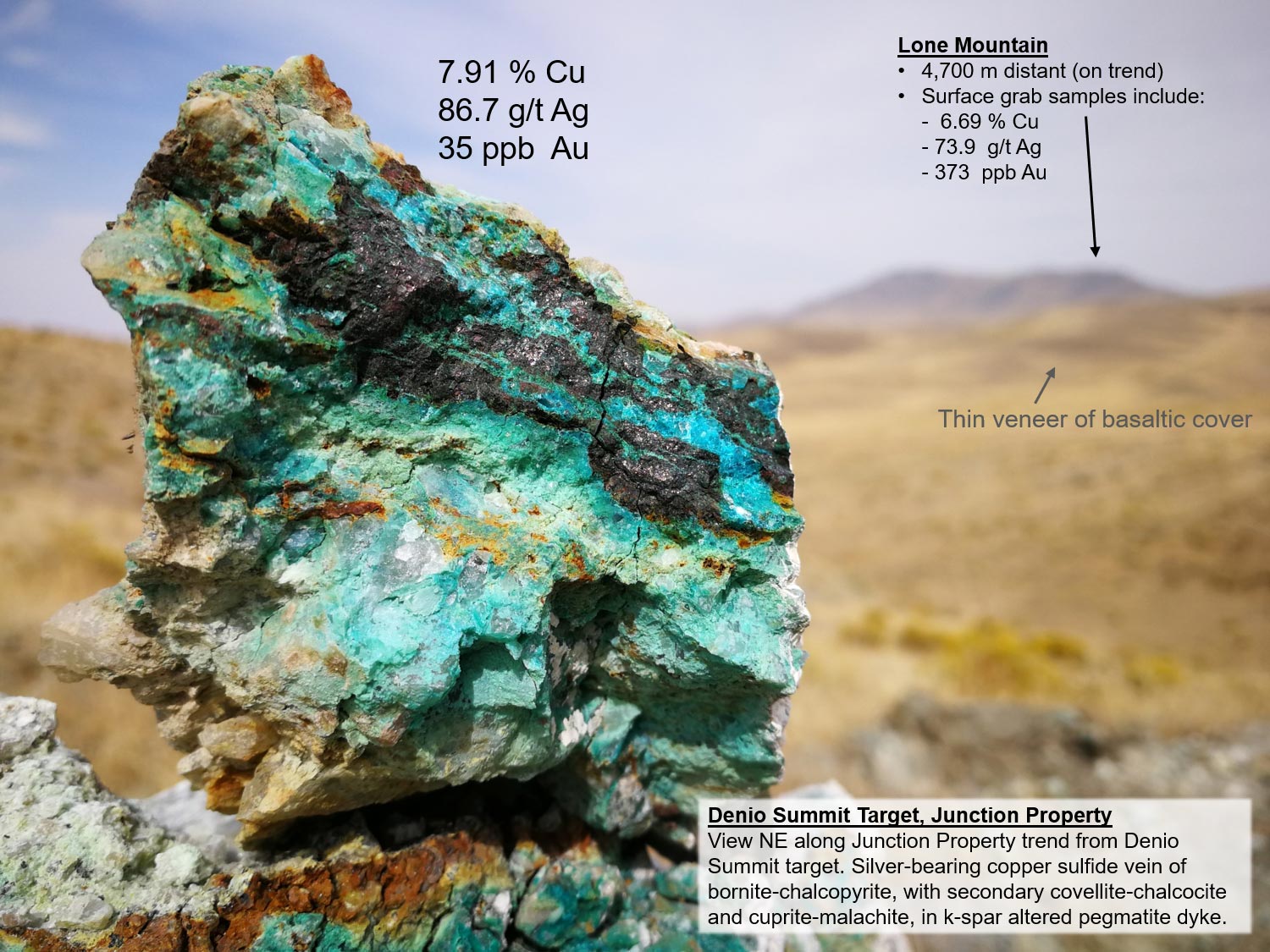
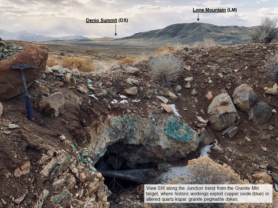
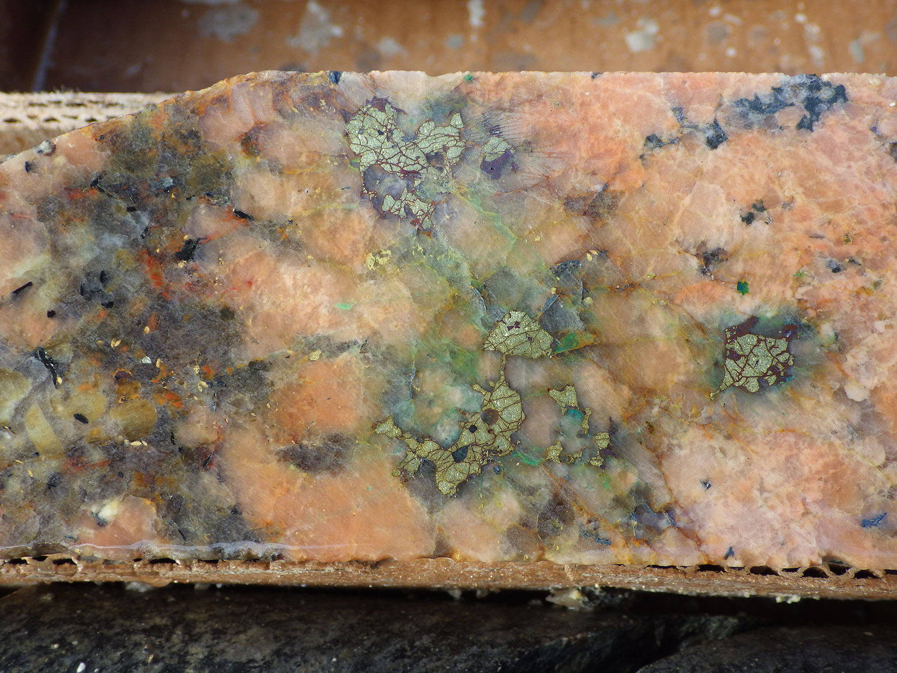
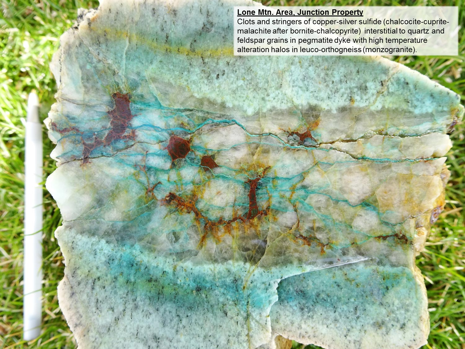
The Junction property follows a 6 kilometre long northeasterly trend of more than 20 individual surface occurrences of polymetallic copper-silver – bearing quartz-feldspar pegmatite dykes, with associated gold-bearing quartz veins at Denio Summit at the western part of the property. The copper-silver pegmatite dykes do not have a metamorphic fabric, and most often crosscut the northeasterly structural grain of the host orthogneiss and migmatite. Quartz, k-feldspar and biotite grains are commonly centimetre-scale in the pegmatite dykes.
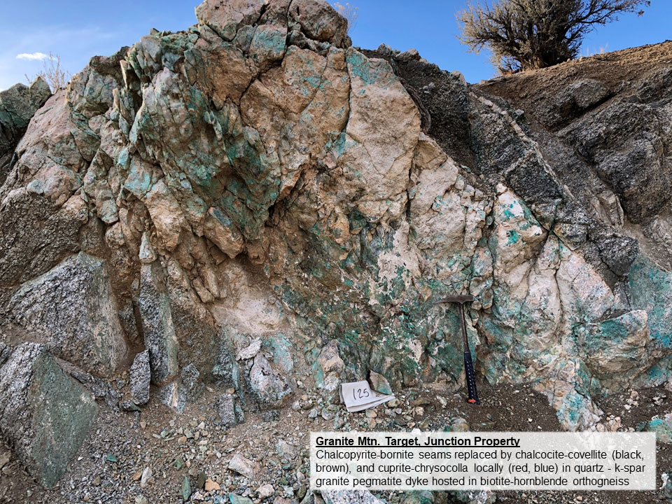
The style of mineralization at Junction is consistent along the 6km length of the trend, amongst the various occurrences in outcrop, old workings (pits and trench cuts, local adits). Centimetre- to decimetre- scale clots and seams of sulfide and mixed sulfide-oxide minerals occur primarily in decimetre- to metre-scale quartz-feldspar pegmatite bodies. There is cluster of historic pits and workings at the Granite Mountain target in the eastern part of the property because there is a swarm of more than a dozen dykes across a zone approximately 300 metres wide. The dykes have a consistent planar geometry overall, with a moderate (45-60 degrees) dip to the northeast. They occur in the core of a concentric elliptical magnetic feature approximately 2.5 kilometres across.
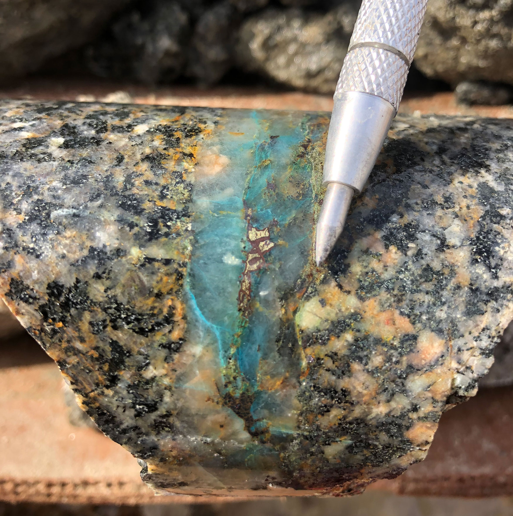
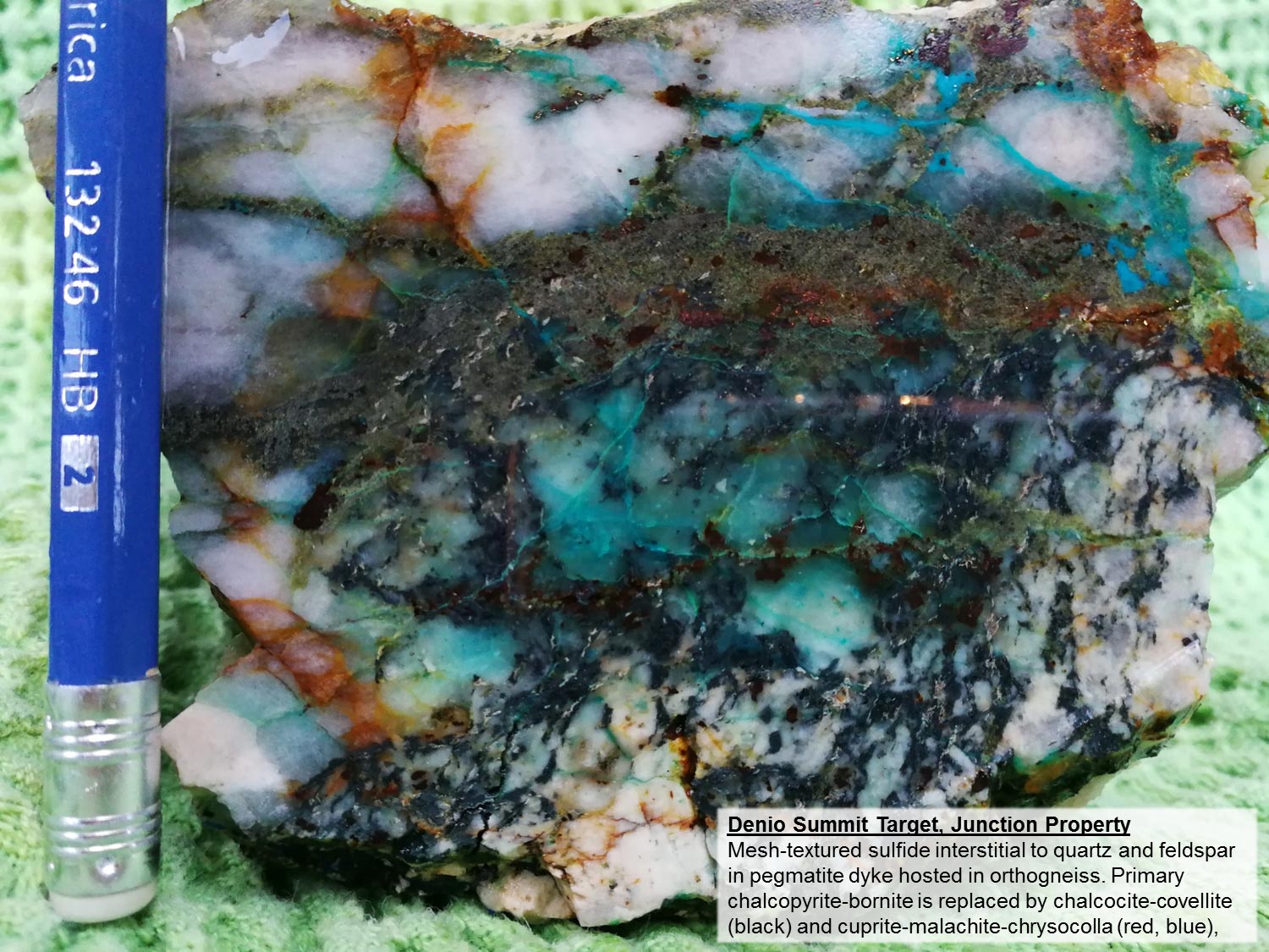
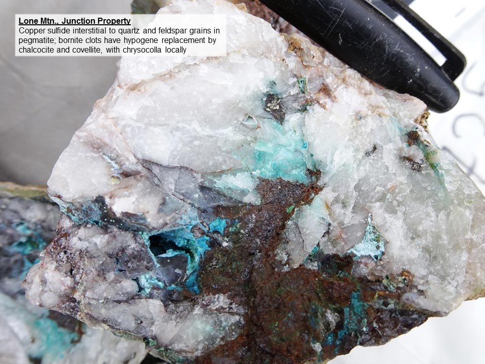
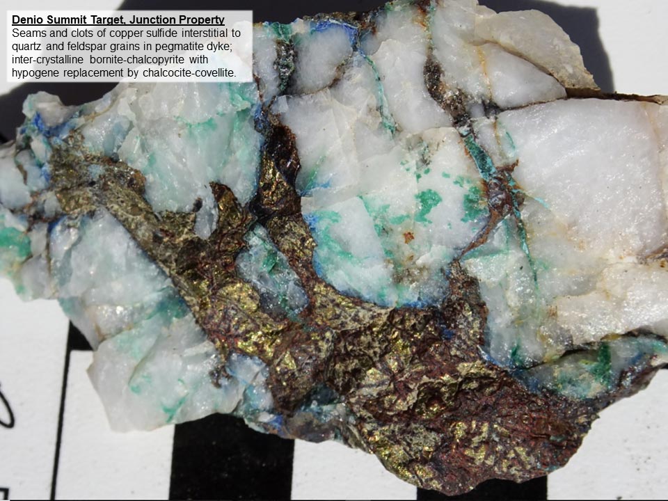
Bornite and chalcopyrite copper sulfides are observed at nearly all of the surface occurrences at Junction. Polycrystalline sulfide aggregates occur interstitial to quartz and feldspar grains in pegmatite, and in locally continuous seams within pegmatite. There is both hypogene and supergene replacement of primary bornite-chalcopyrite at Junction. Evident in nearly all showings along the 6 km trend at Junction is a progressive hypogene replacement outwards from bornite-chalcopyrite grain cores by chalcocite-covellite copper sulfides. Supergene copper oxide occurs locally, by wholesale replacement of copper sulfide by cuprite, and/or, by malachite-chrysocolla as grain coatings or fracture linings.
The statistical correlation of copper to silver is high at Junction (0.88), and consistent, based on a geochemical data set of more than 100 rock samples taken from along the entire 6 km trend of showings. The correlation does not vary amongst the various showings along the trend, nor does it vary depending on the grade of copper or silver in any given sample. The silver is believed to occur as primary micro-inclusions within bornite copper-sulfide grains.
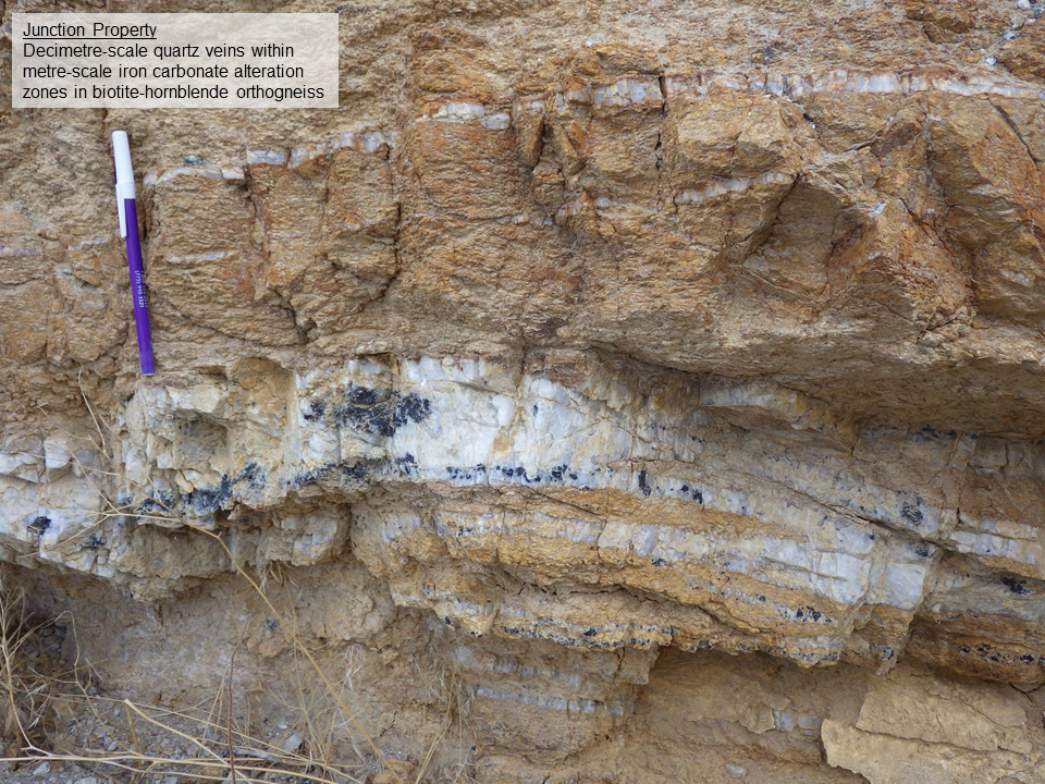
Alteration at surface at Junction is constrained mostly to host pegmatite dykes. Increasing copper mineralization correlates with increasing hydrothermal k-spar, silica and coarse-grained biotite; magnetite is observed locally. The most common wallrock alteration assemblages in host orthogneiss are chlorite-epidote and quartz-sericite, with secondary k-spar locally in proximity to pegmatite dykes. At the Denio Summit target, there are anastomosing quartz veins with metre-scale envelopes of pale brown iron carbonate alteration developed within host orthogneiss.
Porphyry-style potassic alteration and quartz-copper veins are evident in both granite dykes and orthogneiss host rock in drill core from Granite Mountain at the eastern end of the Junction. There is complete textural destruction of the normally well-banded orthogneiss by this alteration, which is characterized by coarse grained, hydrothermal potassium feldspar, biotite and magnetite, and contains disseminated bornite locally in drill hole GR-18-001.
Styles of mineralization similar to Junction occur elsewhere along the northwesterly margin of the Early Cretaceous batholith, most notably at the historic workings of the Ashdown and Hall mines located 10-15 kilometers to the southwest and northwest of Junction, respectively. The Ashdown mine is a the southwestern end of the Antelope Valley shear zone which runs through the Junction property. Quartz veins from 30 centimetres to three metres wide at Ashdown are hosted in gneissic quartz diorite. Gold was the focus of mining in the late 1800’s. Moly was the focus of exploration between 1979 and 1994, with a brief period of production in 2008. Copper, in the form of chalcopyrite, is associated with moly, but is minor. Quartz-sericite alteration is a common vein alteration halo at Ashdown. At the Hall deposit, mixed sulfide-oxide minerals of copper and silver occur as clots and seams within a ten metre wide quartz vein within schist at the contact with a large body of granodiorite.
On a more regional scale, the upside potential of the porphyry-style potassic alteration and copper mineralization discovered in this drill program lies in its age. The Junction property is hosted within a polyphase, middle Cretaceous batholith. It is the same age as the Robinson porphyry copper deposit at Ely in east-central Nevada, with a history that dates back to 1876. Still in production today, KGHM Polska Miedz S.A. operates a large-scale open pit mine to recover copper, gold and molybdenum for export.
VR will advance the Junction project in 2019 based on the porphyry-style mineralization discovered by this drilling, the obvious exploration vectors using resistivity mapping, and the knowledge of a proven and significant analogue of the same age along trend to the southeast at Ely.